Vegetation Management LiDAR for Utility Corridors
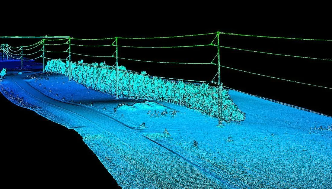
Vegetation management LiDAR is an aerial survey of a transmission or distribution right-of-way that returns a classified point cloud: conductors, structures, ground and vegetation as separate classes, with the distance from every conductor to the nearest vegetation return measured and compared against a clearance threshold. Northern Drone flies it from West Fargo, North Dakota for utilities and vegetation management contractors across the Upper Midwest and nationwide, with data back in 72 hours.
How the FAC-003 clearance workflow runs
The flight is planned from your line list and structure coordinates so the swath covers the full right-of-way width, not just the centerline. The LiDAR is flown with RTK positioning and ground checkpoints so the cloud is tied to your coordinate system and vertical datum. In processing, the cloud is classified and each conductor is extracted as its own line of points. The clearance analysis then measures the distance from each conductor to the nearest vegetation return and flags every location that falls inside the Minimum Vegetation Clearance Distance for that voltage, or inside your own tighter internal thresholds, which most utilities set above the NERC minimum.
The output is a ranked encroachment list with coordinates, span numbers and measured clearances, which is what a vegetation program needs to dispatch trimming crews in order of risk and what a compliance team needs to document the annual inspection.
Why conductor classification is the whole job
A clearance figure is only defensible if the conductor is measured as a conductor. Photogrammetry struggles to reconstruct a thin wire and loses the ground under canopy, so it produces a surface with the trees but not a reliable position for the line. Classified LiDAR resolves each phase individually, which also makes sag measurable at the surveyed temperature and lets the analysis model clearance at maximum operating temperature or under blowout rather than only at the conditions on the day of the flight.
Encroachment that a ground patrol misses
Ground patrols see the corridor from below and from the access road. Grow-in from the side of the right-of-way, fall-in risk from tall trees outside the corridor edge, and vegetation under a sagging mid-span are the cases that produce outages in storms and that a drive-by inspection rates as fine. The classified cloud measures all three. Fall-in analysis uses the measured tree height and position to show which trees outside the corridor could reach a conductor if they failed.
For utility vegetation management contractors
If you hold the trimming or inspection contract, the survey is delivered under your scope and in the format your crews and the utility's GIS already use. A current clearance dataset lets you bid trimming cycles against measured encroachment instead of an estimate, prove completed work with a post-trim flight, and bring the utility a documented FAC-003 inspection as part of the same engagement.
Deliverables
- Classified point cloud (LAS/LAZ) with ground, vegetation, structure and conductor classes
- Clearance analysis against MVCD or your internal thresholds, with every encroachment listed by span and coordinate
- Fall-in and grow-in risk layers, sag at surveyed temperature, and optional modeling at maximum operating temperature
- GIS-ready shapefiles or geodatabase, DXF for design, and a PDF inspection report your compliance team can file
Flight and data collection are performed by Northern Drone. Where a project requires a licensed engineer's review of clearance results, we work alongside your engineer of record. See the LiDAR mapping service page for accuracy figures and how the survey is flown.