Industries We Serve
We don't do generic aerial services. Every industry below has specific data needs, compliance requirements, and risk profiles — and we understand them.
Trees Don't Wait.
Neither Should Your Survey Program.
Vegetation encroachment is consistently the largest single cause of distribution power outages in the U.S. — and NERC FAC-003 makes proactive management a federal compliance requirement, not an option.
Traditional ground-based crews are slow, expensive, and can't safely access high-voltage ROWs at the speed needed to meet annual 100% inspection requirements. Northern Drone deploys LiDAR to classify every point along your corridor — conductors, structure, ground, and vegetation — giving your vegetation management team exact clearance distances and encroachment risk flags before any crew sets foot in the field.
FAC-003-5 (effective April 1, 2024) mandates 100% annual inspection of applicable transmission lines — no more than 18 months between inspections on the same ROW. Violations carry the highest average penalties of any non-CIP NERC standard, with fines exceeding $200,000 per violation and up to $1 million per day.
Industry surveys consistently report vegetation contact as the cause of roughly 20–25% of distribution outages in normal weather and over 85% of trouble spots during major storms. The 2003 Northeast Blackout — triggered by untrimmed trees contacting 345 kV lines — affected ~50 million people and caused an estimated $4–10 billion in economic damages.
Minimum Vegetation Clearance Distances under FAC-003-5 range from approximately 2.4 ft at 230 kV to 11 ft at 765 kV at sea level — calculated using the Gallet equation. Our classified LiDAR point clouds measure every tree-to-conductor distance so your team knows exactly where clearances are marginal before a violation occurs.
U.S. utilities collectively spend an estimated $6–8 billion per year on vegetation management — the largest single line item in most T&D operations and maintenance budgets. Drone LiDAR survey is consistently cited as delivering 50–75% survey cost reductions and 60–80% field time savings compared to ground-crew inspection across multiple independent industry benchmarks.
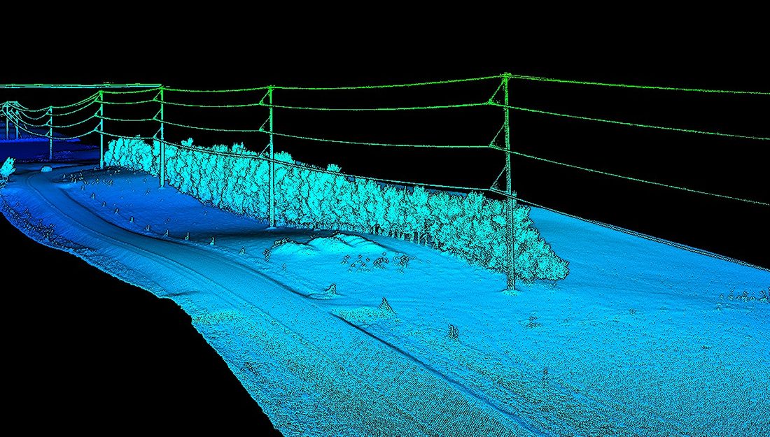
Classified LiDAR point cloud separating ground, vegetation, structure, and conductor returns. Exact clearance distances at every point along the corridor. Encroachment risk flags keyed to your MVCD thresholds. Delivered in LAS/LAZ, GIS-ready formats, and a PDF report your compliance team can act on immediately.
Survey Your Corridor. Hit Your Compliance Window.
FAC-003-5 requires 100% annual inspection. We can cover your transmission ROW faster and at lower cost than ground crews — with a classified LiDAR deliverable your compliance team can use on day one.
Know Your Pit.
Without Putting Anyone In It.
Flooded quarry pits are among the most hazardous environments in mining operations. Getting accurate depth, volume, and sediment data from them traditionally meant dive teams or boat-based sonar — both slow, expensive, and genuinely dangerous.
Northern Drone deploys sonar-equipped USV platforms to map flooded quarry pits with ±2 cm depth accuracy and centimeter-level positioning. You get color-coded depth maps, cross-section profiles, full point clouds, and CSV exports with Easting/Northing/Z-values — everything needed for dewatering planning, reclamation permitting, sediment management, and extraction decisions. No personnel in the water. No operational downtime.
Commercial diving is among the most hazardous occupations — fatality rates orders of magnitude above general industry. Flooded quarry-specific risks include near-zero visibility, submerged highwall slumps, thermoclines, entanglement, and differential pressure at pump/intake structures (a leading cause of fatal commercial diving incidents in inshore environments per ADCI/OSHA).
Dual-frequency sonar (200 kHz / 50 kHz) maps both the sediment surface and the hard bottom beneath — sand, clay, or rock. A documented quarry case study (SPH Engineering / Knife River, Texas, 2024) detected sediment layers to 30+ ft depth in a single survey day with no personnel in the water.
MSHA (30 CFR Parts 56/57) requires accurate mine maps, hazard assessments, and rapid reporting of unplanned flooding. State reclamation authorities frequently require volumetric data for permit compliance. Our georeferenced deliverables are formatted to support these reporting requirements directly.
Sediment accumulation rates, water level changes, and pit geometry shifts are only visible with repeat surveys. We can return quarterly, annually, or after major events to build a longitudinal record of your water asset — enabling proactive management before issues affect operations or compliance.
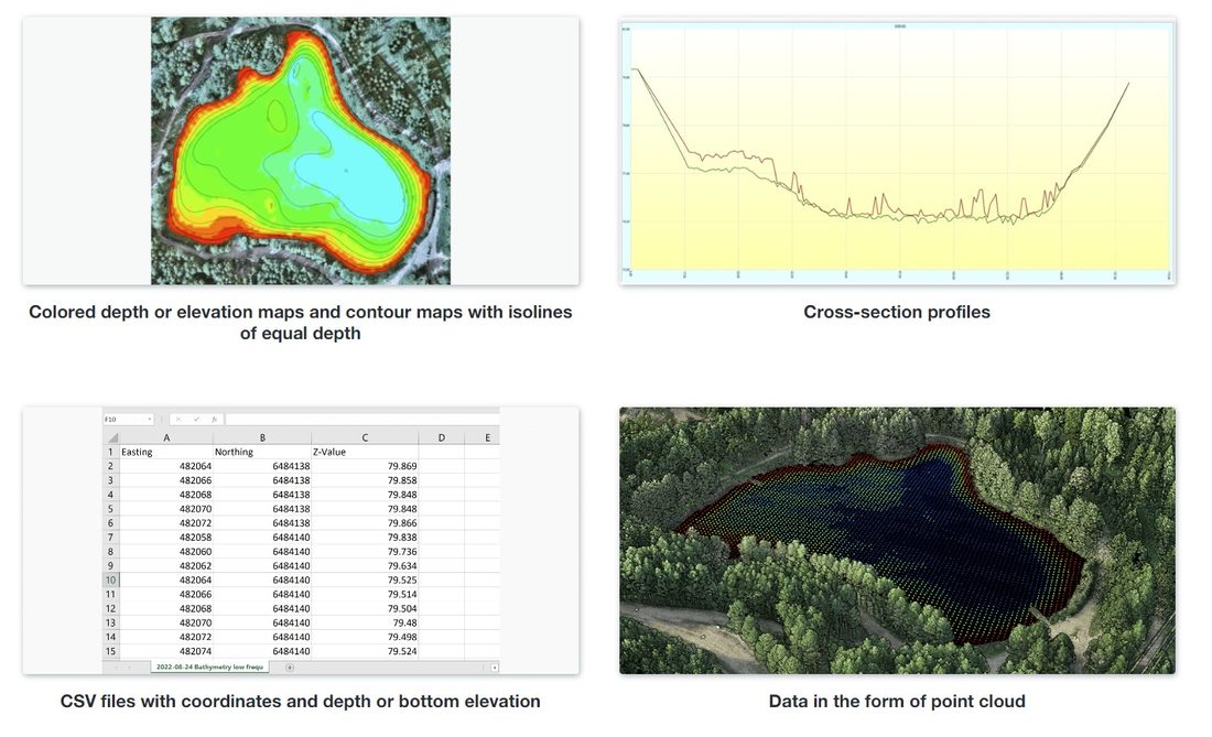
Every bathymetric survey includes: color-coded depth contour map with isolines, cross-section profiles, georeferenced point cloud, CSV export (Easting / Northing / Z-Value), and volume calculations. All data is GIS-ready and formatted for your engineering team, reclamation consultant, or regulator.
Map Your Pit. No Dive Crew Required.
One survey day. No personnel in the water. Complete depth, volume, and sediment data ready for your engineering team within 72 hours.
Better Data Before
Ground Is Broken.
Construction rework costs the industry an estimated 5–9% of total project contract value — and nearly half of that is directly attributable to inaccurate or inaccessible site information. Getting the survey right before excavation starts is the single highest-leverage intervention a project team can make.
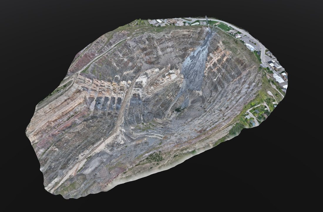
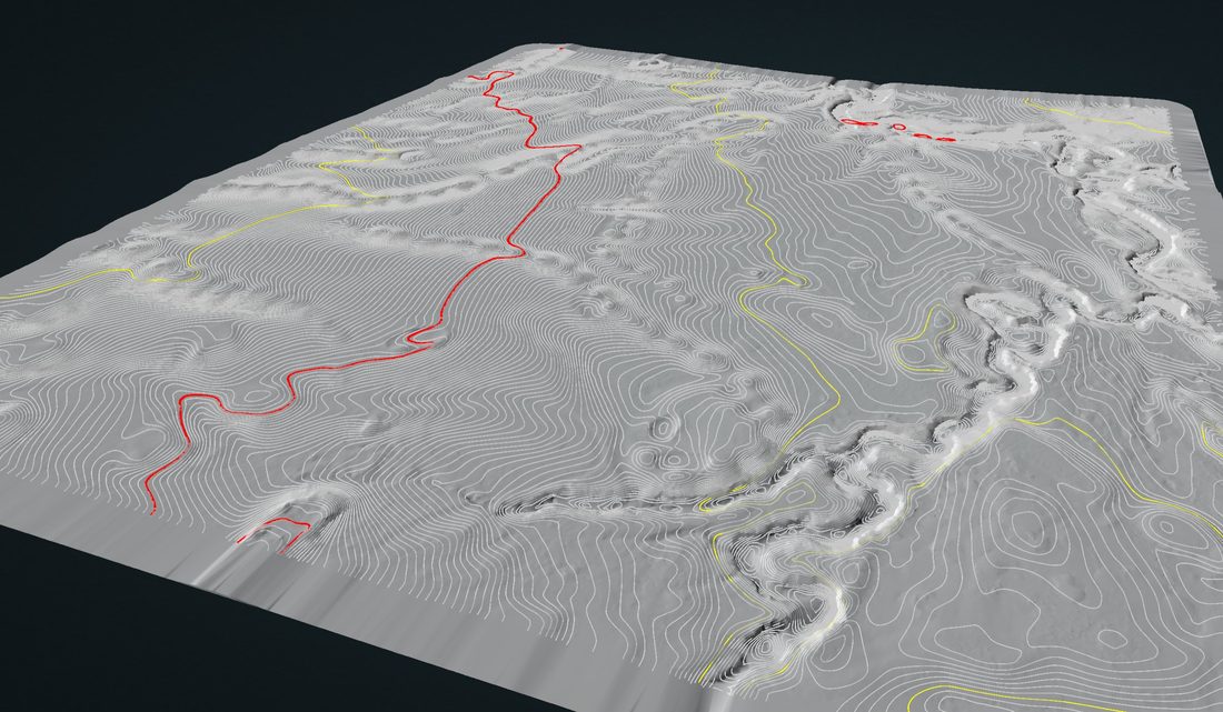
Northern Drone provides LiDAR and photogrammetry-based topographic surveys, cut/fill volume calculations, progress monitoring, and as-built documentation for construction and civil engineering projects of any size. Drone LiDAR achieves 4–5 cm vertical accuracy with RTK correction — meeting ASPRS Positional Accuracy Standards for engineering-grade work — at a fraction of the cost and time of traditional ground crews.
Full DTMs, contour maps, drainage analysis, and cut/fill volume calculations before ground is broken. Drone topo surveys consistently cost 50–75% less than traditional ground survey for sites over 5 acres, with field time reductions of 60–80% — multiple independent industry benchmarks are directionally consistent on this range.
Photogrammetric stockpile volume measurement achieves approximately 1–5% accuracy versus ground survey, with 2% routinely cited as best-in-class under good conditions. We cover active sites without halting operations — giving project managers real inventory numbers on schedule, not estimates.
Regular aerial surveys throughout the project lifecycle create a time-stamped visual and volumetric record. Orthomosaics, point clouds, and 3D models let project managers, engineers, and owners track progress, verify as-built conditions, and identify deviations before they become expensive corrections.
Active excavations, steep slopes, contaminated ground, and bridgework are difficult or dangerous for ground survey crews. Drone platforms access these areas safely and efficiently, reducing the need for personnel in hazardous conditions while providing more complete spatial coverage than ground-based methods alone.
DTM / DEM / DSM, contour maps, cut/fill volumes, orthomosaics, classified LiDAR point clouds (LAS/LAZ), GeoTIFF rasters, DXF/DWG for CAD, KMZ/SHP for GIS, and PDF progress reports. All formatted to integrate with your existing project management and design workflows.
Get the Survey Data Your Project Needs.
Pre-construction topo, progress monitoring, or as-built documentation — we deliver engineering-grade data faster and at lower cost than traditional ground survey. Tell us your project and we'll scope it within one business day.
Know Exactly What
You Have. Every Time.
Whether you're managing aggregate inventory, tracking material movements at a quarry, or reconciling stockpiles at a cement plant — accurate volume data is the difference between confident operations and expensive surprises.
Northern Drone flies photogrammetric surveys of stockpile sites and delivers accurate volume calculations within 1–2% of ground truth under good conditions — faster, safer, and at a fraction of the cost of traditional survey methods. No crew on the pile. No halting operations. Just reliable numbers your team can act on.
A traditional survey crew walking a stockpile yard takes hours or days depending on site size. A drone survey covers the same area in minutes and delivers processed volume calculations within 24–72 hours. Operations keep running — no shutdown, no traffic management, no safety exclusion zones for ground crews.
Photogrammetric stockpile volume measurement consistently achieves 1–2% accuracy compared to ground truth under good flying conditions with proper ground control. That's engineering-grade inventory data — precise enough for invoicing, reconciliation, financial reporting, and permitting purposes.
Aggregate, sand, gravel, crushed stone, topsoil, coal, woodchip, grain, salt — if it's piled outside, we can measure it. Multi-stockpile sites, active quarry yards, port terminals, rail transfer facilities, construction staging areas. We've surveyed sites with dozens of individual piles in a single flight session.
Monthly or quarterly volumetric surveys build a running inventory record that flags shrinkage, theft, settling, and measurement discrepancies before they compound into major financial losses. Many of our clients run recurring survey programs that replace manual tape-and-factor estimates entirely.
Per-pile and total volume calculations, orthomosaic of the full site, color-coded surface model, cut/fill comparison against a reference surface (if provided), and a clean summary report formatted for inventory management, financial reporting, or permit compliance. All data in GIS-ready formats plus PDF summary.
Aggregate quarries, ready-mix and concrete producers, construction site staging, mining operations, grain and agricultural cooperatives, port and rail transfer terminals, waste management facilities, road construction contractors, and earthwork/grading companies.
Stop Estimating. Start Knowing.
Tell us your site size, number of piles, and how often you need surveys. We'll put together a program that replaces your manual estimates with data you can actually stake decisions on.
See What's
Under the Surface.
Ground-penetrating radar from a drone platform brings sub-surface investigation to terrain that is too hazardous, too wet, or too remote for traditional cart-based GPR crews. It is one of the most technically demanding services we offer — and one of the most valuable for the right project.
Drone GPR flies 1–3 meters above the ground, transmitting radar pulses downward and capturing reflections from sub-surface boundaries — soil layers, voids, buried infrastructure, and geological features. Northern Drone operates FCC Part 15 / §15.509-compliant GPR systems on qualifying projects including commercial mining, construction, and scientific research applications.
GPR depth and resolution are determined by antenna frequency. Higher frequency (500–1000 MHz) achieves 1–5 m penetration with ~5–15 cm resolution — suitable for utility detection, shallow geology, and void identification. Lower frequency (100–250 MHz) reaches 5–20 m with coarser resolution — suited for deeper geological surveys. All figures assume typical soil dielectric properties and degrade significantly in high-clay, high-moisture, or saline ground.
Drone GPR's advantage is access — not absolute resolution. It excels in hazardous or inaccessible terrain: active quarries, contaminated sites, steep embankments, and areas with standing water or unstable ground. Documented applications include utility detection, void/sinkhole assessment, sub-surface geological mapping, forensic investigation, and UXO/buried-object detection in hazardous environments.
Ground-coupled GPR delivers higher signal-to-noise ratio, deeper effective penetration, and better local-target resolution than airborne GPR — because direct ground contact maximizes energy transfer. Drone GPR trades some resolution for speed and access. For large, inaccessible, or hazardous areas, drone GPR is the right tool; for precise utility locating in accessible terrain, ground-coupled GPR remains superior. We'll tell you which is right for your project.
Drone GPR in the U.S. operates under FAA Part 107 (platform) and FCC 47 CFR §15.509 (GPR emissions). FCC §15.509 restricts GPR use to specific eligible parties including commercial mining, construction, and scientific research. We operate compliant systems on qualifying projects and coordinate with applicable regulatory requirements on every deployment — this is not a gray area we ignore.
FCC §15.509 was written for ground-coupled GPR. Airborne deployment in the U.S. requires either (a) eligibility under one of the specified use categories (mining, construction, emergency services, scientific research) or (b) an FCC waiver on a case-by-case basis. We operate within these requirements — and we disclose this upfront because we believe you deserve accurate information about the regulatory framework around the services you purchase.
Have a Site That Needs Sub-Surface Data?
Tell us about your project — terrain type, target depth, and access constraints — and we'll tell you honestly whether drone GPR is the right tool or whether a different approach would serve you better.
Every Faulty Panel Is Revenue Walking Out the Door.
Solar farms are generating power and losing money simultaneously. A single underperforming string, bypass diode failure, or hotspot can drain thousands of dollars in annual revenue — often invisible to SCADA monitoring and undetectable without thermal imaging.
Northern Drone deploys radiometric thermal drone surveys to identify faults at the panel level across utility-scale and commercial solar installations — while the array keeps generating. We deliver geo-referenced fault maps, severity rankings, and IEC 62446-3 compliant inspection reports ready for your O&M workflow. No scaffolding. No production shutdown. No guesswork.
Radiometric thermal imaging identifies hotspots, bypass diode failures, cell cracks, delamination, soiling, PID effects, string outages, and shading losses — faults that inverter-level monitoring misses entirely. Manual ground checks typically sample only 10–25% of an array. Drone surveys cover 100% in a single session.
A 5% undetected yield loss on a 10 MW site costs approximately $40,000 annually in lost revenue. Raptor Maps reports drone thermal inspections saved $788 million across PV systems in 2025 — averaging $2,100 per MW inspected in recovered production losses and reduced labor costs. Drone inspection typically cuts inspection time by up to 75% vs. manual methods — a 20 MW site completed in 2–4 hours instead of 20+ days.
IEC 62446-3 is the international standard for thermographic PV inspection. Day-zero drone thermal surveys create a compliant baseline record, flagging installation defects before energization — giving EPCs and asset owners documented evidence for warranty claims and insurance submissions. Northern Drone documents irradiance (minimum 600 W/m²), wind, and time-of-day on every inspection as required by the standard.
Commercial rooftop systems face the same fault types as utility-scale farms — but with added working-at-height risk and limited access for ground crews. Drone thermal inspection eliminates those hazards entirely, covering the full array in a single flight and delivering a panel-level fault map without a technician stepping on the roof.
Geo-referenced fault map with every anomaly pinpointed to panel coordinates. Severity classification — critical, moderate, monitor. Thermal and RGB imagery pairs for each fault. Annual kWh and revenue loss estimate per unresolved issue. IEC 62446-3 compliant PDF inspection report formatted for your O&M team, asset manager, or EPC.
Multi-MW PV plants — annual or biannual full-site inspections for asset managers and O&M teams.
Full-array coverage in one flight. No technicians on the roof. Panel-level fault map delivered.
Day-zero IEC 62446-3 commissioning surveys before energization for warranty and insurance documentation.
Find Out What Your Array Is Hiding.
One thermal survey flight covers your full site and delivers a panel-level fault map within 72 hours. Tell us your site size and we'll scope it within one business day.