Drone LiDAR Mapping: Seeing Through the Canopy to True Bare Earth
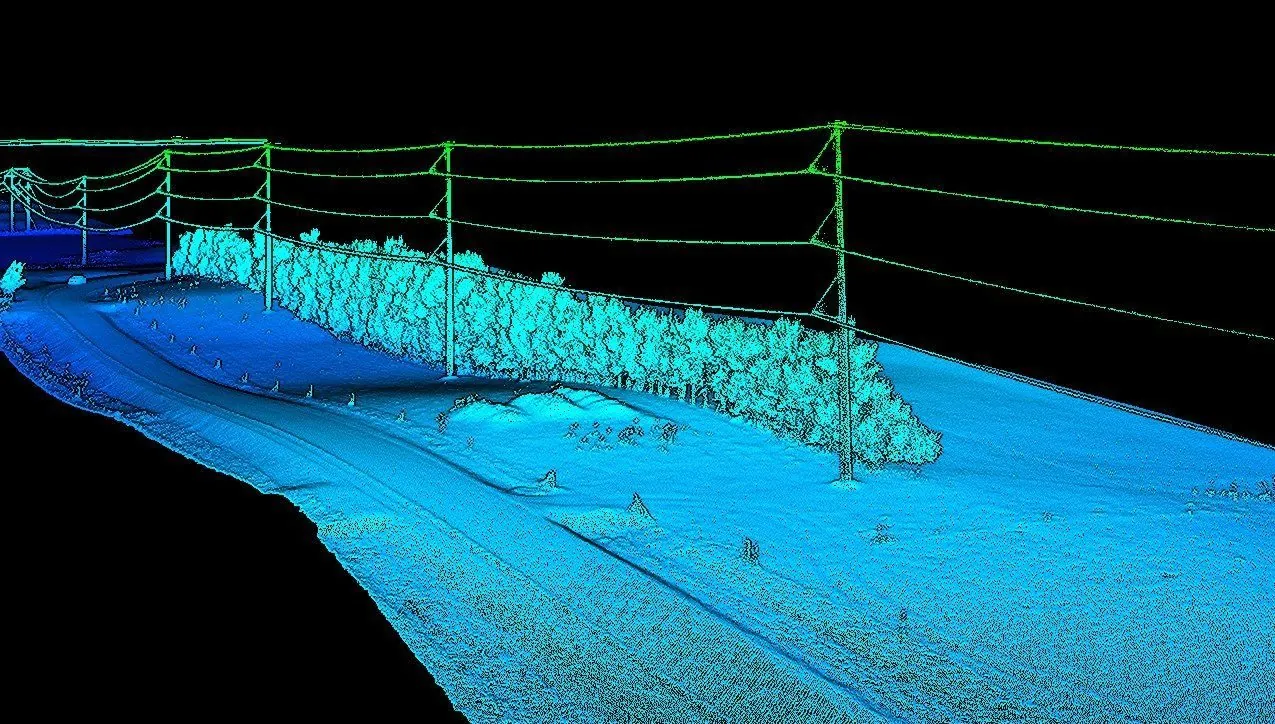
Traditional ground survey stops at the tree line. A crew with a total station maps open ground accurately, but add dense vegetation, steep terrain, or a live powerline corridor and the work gets slow, expensive, and hazardous. Drone LiDAR was built for exactly that problem.
This is a plain-English look at how it actually works, what the accuracy figures mean once you interrogate them, and where the extra cost over photogrammetry is and is not justified.
How LiDAR Sees Through Vegetation
The sensor fires laser pulses toward the ground and times each return. Many strike leaves and branches. A portion slip through gaps in the canopy, reach the soil, and come back as a later return from the same pulse.
That last part is the whole trick. Because a single pulse can produce several returns — canopy top, understory, then ground — the returns can be separated in processing. Classify the ground returns and you have a bare-earth surface beneath the vegetation.
It is worth being precise about the mechanism, because "LiDAR sees through trees" is a claim people reasonably distrust. It does not penetrate foliage. It finds gaps. On dense evergreen canopy in full leaf the proportion of pulses reaching the ground drops sharply, which is why heavy cover gets flown lower and at higher pulse density — you are buying more chances at the same gaps.
Why Photogrammetry Cannot Do This
Photogrammetry builds a surface by matching features between overlapping photographs. It is excellent on bare ground, roads, stockpiles, and open sites — often better value than LiDAR for those.
But a camera can only model what it can see. Put a canopy over the ground and photogrammetry reconstructs the top of the vegetation and reports it as terrain. It does not fail visibly. It produces a smooth, confident, entirely wrong surface, and unless you have something to check it against, nothing about the output announces the problem.
That single distinction is the reason LiDAR costs more, and the only reason to pay for it. Open field: use photogrammetry. Wooded corridor, brush-filled drainage, transmission right-of-way: LiDAR or nothing.
What the Accuracy Number Actually Means
Accuracy in this industry gets quoted as a single figure without saying which accuracy is meant. There are three, and they are not interchangeable.
- Relative accuracy — how internally consistent the cloud is. Determines whether contours look smooth or noisy and whether two flights can be compared. Usually the best of the three numbers.
- Absolute vertical accuracy — how closely an elevation matches a surveyed benchmark. This is the one that matters for engineering design, permitting, and anything tying into a project datum. It depends heavily on ground control.
- Absolute horizontal accuracy — typically better than vertical, rarely the limiting factor, but relevant for utility locates and boundary-adjacent work.
We publish ±2–5 cm vertical because that is repeatably achievable on a real project with an RTK base on site and independent checkpoints flown and verified afterward. Without ground control, absolute vertical drifts — fine for comparing one flight against another, not fine for a design deliverable.
How Accuracy Is Formally Specified
If you are writing a survey into a contract, it helps to know how the standard actually works, because it changed and a lot of marketing has not caught up.
The current reference is the ASPRS Positional Accuracy Standards for Digital Geospatial Data, Edition 2. Two things about it are worth knowing:
- There are no named accuracy tiers. The standard is data-driven — you specify the accuracy your project needs, and that figure becomes the accuracy class, expressed as RMSE. So "meets ASPRS engineering-grade standards" is not a meaningful statement; a number is.
- RMSE is the only accepted measure. Reference to the 95% confidence level was eliminated, and the accuracy of your ground control and checkpoint survey now has to be folded into the reported product accuracy — you cannot treat control as error-free. The USGS summary of the changes is the clearest short read on it.
For context on what public-sector elevation data targets: USGS 3D Elevation Program Quality Level 2 specifies RMSEz under 10 cm at 2 points per square metre. A well-controlled drone LiDAR survey comfortably exceeds both, which is why this platform has moved into work that used to require manned aircraft.
Point Density and What It Buys
Density is quoted in points per square metre and is frequently oversold. More is not automatically better — it is more flight time, more storage, and more processing.
- Open terrain rarely justifies more than 50–100 pts/m². Beyond that you are describing a surface that is already fully described.
- Heavy canopy is where high density earns its cost, up to around 300 pts/m². Only a fraction of pulses reach the ground, so total density has to rise for ground-return density to stay usable.
- Fine feature extraction — conductors, curb lines, small drainage structures — needs density matched to the feature size, not to the site.
The number worth asking about is not points per square metre. It is ground points per square metre after classification, under your actual vegetation. That is the figure that determines whether your bare-earth model is real.
If a vendor quotes an accuracy figure without stating the ground control it assumes and the checkpoint residuals achieved, the number is marketing. Ask what the residuals were.
Classification Is Where the Value Is
A raw point cloud is not a deliverable. Every return has to be sorted into what it hit: ground, low vegetation, high vegetation, buildings, and — on utility work — conductors resolved individually from everything around them.
That classification is what turns a cloud into answers. Conductor points separated from vegetation points are what make a clearance measurement defensible rather than approximate. Ground separated from understory is what makes a hydraulic model trustworthy. It is also the step where quality varies most between providers, because it is the step that takes time.
Where It Earns Its Cost
Utility and transmission corridors
Conductor sag, vegetation encroachment, and clearance to structures measured from a classified cloud — no climber, no bucket truck, no outage. Under NERC FAC-003 this is compliance work, not optional maintenance, which is why utilities buy it on a schedule. More on that on our power and utility page.
Pre-construction and engineering
A bare-earth DTM with contours before ground is broken gives accurate cut and fill volumes and lets drainage be designed against real terrain rather than an assumed grade.
Flood and drainage modeling
Hydraulic models are only as good as the terrain under them. Vegetated channels and ditch networks are exactly where photogrammetric surfaces mislead and exactly where LiDAR changes the answer.
Forestry and vegetation management
Canopy height models, stand density, and growth between flights all come out of the same dataset that produced the ground surface.
What You Should Receive
- Classified point cloud in LAS or LAZ, with the classification scheme documented
- Bare-earth DTM and full-surface DSM as GeoTIFF
- Contours at your interval, as DXF for direct CAD use
- Breaklines and feature linework where the design workflow needs them
- An accuracy report stating control used, checkpoint residuals, and achieved RMSE — so your engineer accepts the data on evidence rather than trust
Coordinate system and vertical datum get confirmed before the first flight, not after. Being handed a beautiful point cloud in the wrong projection is one of the more expensive avoidable mistakes in this business.
When Not to Buy It
LiDAR is not the right answer everywhere, and quoting it where it is not needed is how you lose a client permanently. Open ground with no vegetation, straightforward stockpile volumes, and visual condition assessment are all better served by photogrammetry or standard imagery at a fraction of the cost.
If your project falls into that category we will scope it that way and tell you why. The reason to fly LiDAR is that the ground is hidden — if it is not hidden, you are paying for a capability you are not using.
Full method, deliverables, and accuracy detail on the drone LiDAR mapping page.
Need Terrain Data Through Vegetation?
Tell us your site and we'll scope a LiDAR survey built around your accuracy and deliverable needs.