Drone GPR for Bedrock Depth: Reading the Data
Before a foundation gets designed, somebody has to answer a simple question: how far down is the rock? Get it wrong on the low side and you are re-engineering footings mid-project. Get it wrong on the high side and you have paid for over-excavation that was never needed.
The standard answer is a drilling program — accurate at each borehole, and blind everywhere in between. On a large site the holes might be a hundred feet apart, and the surface you draw between them is an assumption. Airborne ground-penetrating radar fills that gap: it will not replace the boreholes, but it will tell you where to put them and what the rock is doing between them.
What Airborne GPR Is Actually Measuring
GPR transmits a radar pulse into the ground and times the returns. Where the pulse crosses a boundary between materials with different electrical properties — soil to rock, dry to saturated, fill to native ground — part of the energy reflects back. Timing those reflections and converting them to depth gives a profile beneath every metre the antenna travels.
Flown from an aircraft, the antenna is slung below and held at a constant height above grade. That constant height matters more than anything else in the flight: vary it and the geometry of every trace changes, which corrupts the section in ways that are difficult to unpick afterward. Holding it steady over uneven ground is most of the operational skill in this work.
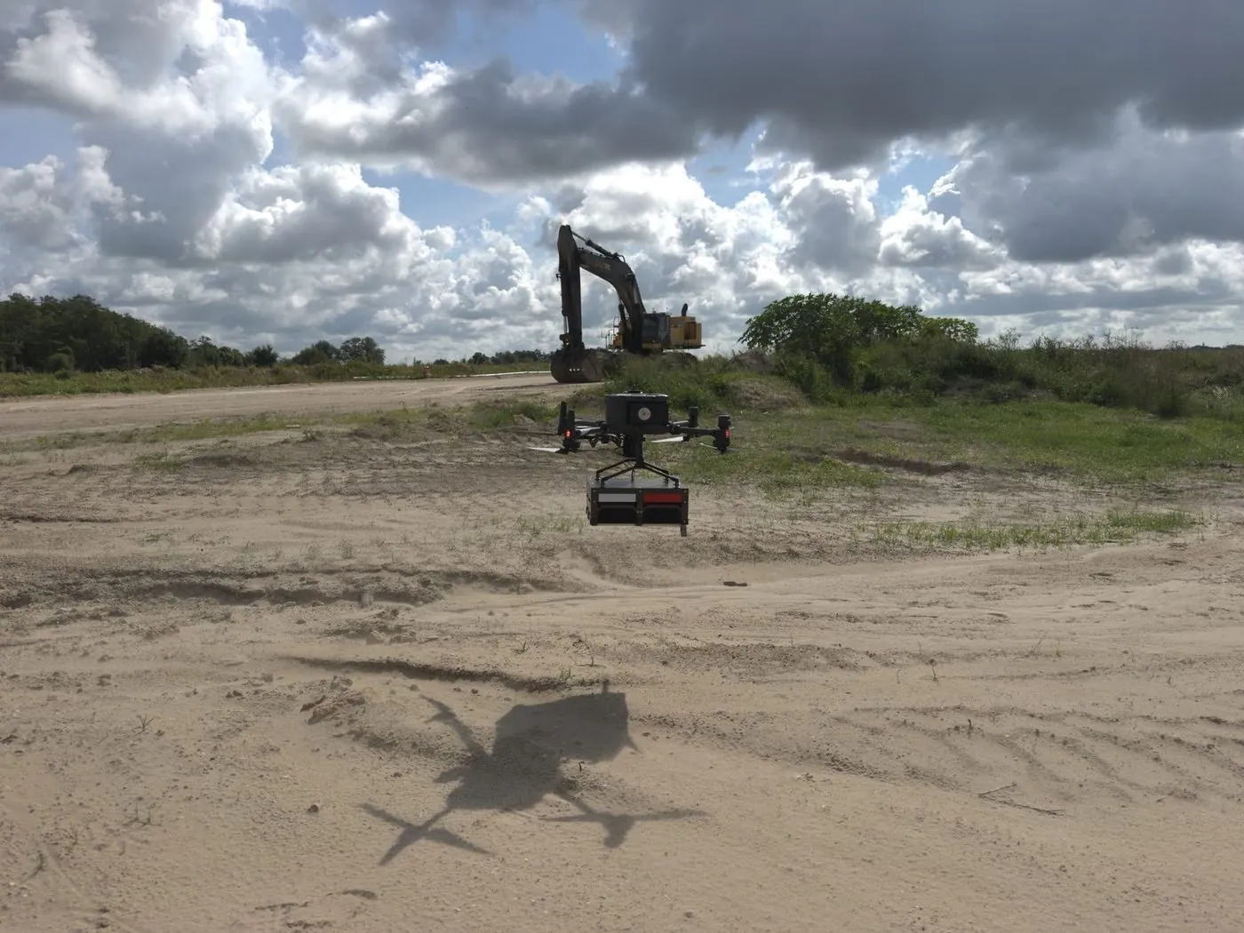
Profiling bedrock depth across an active construction site. The antenna is slung below the aircraft and flown at a constant offset above grade.
What the Processed Surface Looks Like
The radar section is raw material, not the deliverable. Every trace gets a picked horizon — the depth at which the bedrock return appears — and those picks are positioned by RTK and interpolated into a surface.
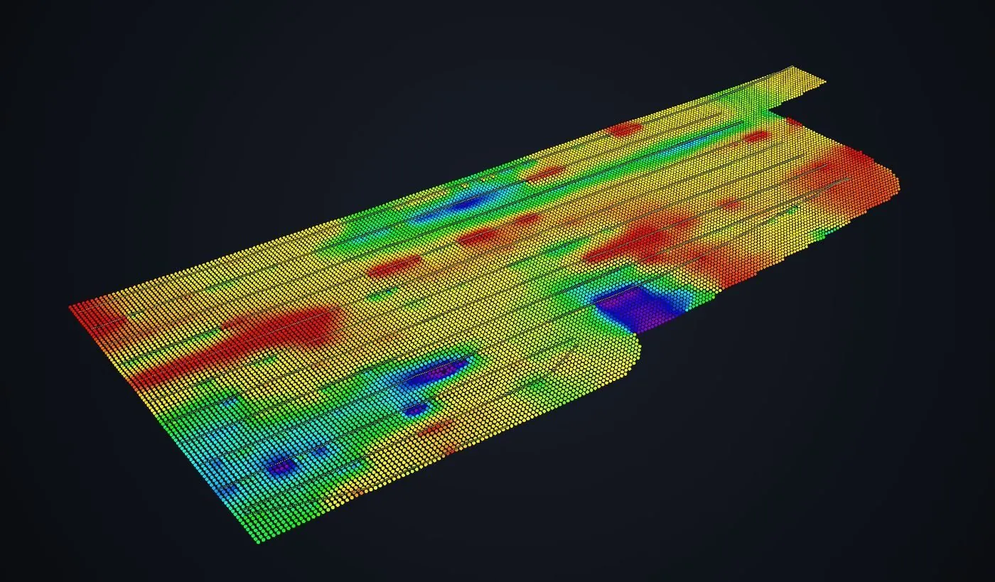
Interpolated rock-layer surface from picked GPR horizons. Warm colors are shallow rock, cool colors deeper.
Two Things Worth Noticing in That Image
The flight lines are visible in the point structure. That is deliberate on our part rather than something to hide. Depth was measured along those lines; everything between them is interpolation. Being able to see where the data actually came from is what lets your engineer judge whether the coverage supports the conclusion, instead of taking a smooth surface on trust. A vendor who renders the same dataset as a seamless blanket has not given you more information — they have hidden the only thing you needed to assess it.
The anomalies repeat across adjacent lines. This is the single most useful test for whether a feature is real. A genuine geological feature — a shallow ridge, a deep channel cut into the rock — appears on every line that crosses it, in a consistent position. A processing artifact or a single bad trace shows up on one pass and nowhere else. When you are looking at a GPR interpretation, ask whether the flagged features persist line to line.
Depth Depends on the Ground, Not the Brochure
The question every client asks first is how deep the radar sees. The honest answer is that it depends almost entirely on what is above the target.
- Dry sand, gravel, and competent rock are close to ideal. Signal travels well and useful depth sits at the top of the range. The site in the images above is sandy fill, which is why it profiled cleanly.
- Silt and loam perform moderately, degrading as moisture rises.
- Wet clay is the worst case by a wide margin. It is electrically conductive and attenuates the pulse aggressively, sometimes limiting useful penetration to a fraction of what the same antenna achieves in sand a mile away.
Antenna frequency sets the other half of the trade. Lower frequency reaches deeper and resolves less detail; higher frequency resolves fine features and stops shallower. There is no setting that gives you both, and choosing wrong wastes the mobilization. On an unfamiliar site the responsible move is a short test line before committing to a full survey grid.
Where the Processing Can Mislead
GPR sections are gained — amplified with depth to compensate for signal loss — and that gain is a judgement call. Applied too aggressively it manufactures reflectors that are not there, producing a section full of confident-looking horizons that mean nothing. It is the most common way GPR data gets over-interpreted, and it is invisible in the final image unless the processing chain is documented.
Every survey we deliver states the chain in order: time-zero correction, resampling, dewow, background subtraction, gain, then horizon picking. If a report does not tell you what was done to the data, you cannot assess what the data is worth.
Ask two questions of any GPR deliverable: what velocity was used for depth conversion, and what gain was applied. Vague answers to either mean the depths are decorative.
What This Does and Does Not Replace
It does not replace drilling. Boreholes give you material properties, sample recovery, and a directly measured depth at one point. GPR gives you continuity between those points and tells you where the interesting variation is.
Used together, the drilling program gets cheaper: instead of a uniform grid of holes on the assumption that the rock surface is flat, you place holes where the radar shows the surface changing. That is usually fewer holes, better positioned, and a more defensible model at the end.
When Not to Fly It
If the site is small, accessible on foot, and you need maximum depth or resolution, a ground-based cart survey will outperform an airborne one and cost less — the antenna couples directly to the soil, which airborne work sacrifices. If your ground is saturated clay, expect limited penetration regardless of platform, and we will say so before quoting rather than after. And if you only need depth at three specific points, drill three holes.
Airborne GPR earns its cost where the ground cannot be walked safely or efficiently: active construction sites with moving equipment, unstable fill, flooded or boggy ground, contaminated areas, or dense brush. That is when flying the antenna stops being a convenience and becomes the only way the survey happens at all.
Full method, deliverables, and accuracy detail on the drone GPR survey page.
Need Bedrock Depth Before You Drill?
Tell us the site, the soil if you know it, and what the data has to support. We will tell you honestly whether airborne GPR fits or whether a ground survey would serve you better.
Request a Free Quote